Charlotte Weather: What to Expect This Week and How to Stay Prepared
Charlotte weather can be unpredictable. If you live in the Queen City or the surrounding areas, staying up to date with the latest weather information is crucial. Whether you’re planning your week, commuting, or just stepping outside with family, it pays to know what’s ahead. In this article, we’ll break down the latest updates for Charlotte and neighboring regions. We’ll cover rainfall outlooks, flood risks, and what locals can expect in the coming days.
Current Charlotte Weather Overview
Rain and thunderstorms have been frequent in Charlotte over the past few days. Much of North Carolina, including areas near Charlotte, is experiencing significant rainfall and periodic storm activity. Residents have noticed cooler temperatures and lingering showers that disrupt daily routines. These conditions are expected to continue before a transition to warmer and drier weather toward the end of the week.
Rain, Flooding, and Safety Concerns
Pockets of heavy rain have caused concerns for flooding, especially around the Blue Ridge Mountains and foothills near Charlotte. According to meteorologists, a recent surge of downpours and thunderstorms has triggered Flood Watches for select regions. Rainfall totals of three to five inches are possible, with isolated areas seeing up to eight inches. This kind of weather pattern means creeks and streams must be watched closely, even in areas that have been dry lately.
Certain communities in North Carolina are still recovering from last year’s historic flooding. The recent storms have again put them on alert. Local authorities are urging people in low-lying regions to stay prepared. Flash flooding can happen suddenly, so keep your mobile devices charged and monitor alerts.
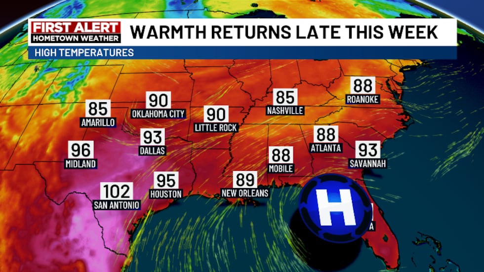
The Next Few Days: When to Expect a Change
The forecast signals more scattered showers on the way. Occasional thunderstorms cannot be ruled out. However, as we get closer to Thursday, meteorologists predict warmer and drier air will return to the region. Highs could approach 90 degrees by Friday, marking one of the warmest stretches so far this year. While this may help dry out the area, it also brings the chance of new late-day storms due to increased heat and humidity.
If you’re planning commutes or outdoor activities, prepare for wet mornings and scattered afternoon showers for at least the first half of the week. Give yourself extra time for the drive and remain cautious on the roads when rainfall is heaviest.
Severe Weather: Tornado and Thunderstorm Updates
Though Charlotte has avoided the worst of severe weather, surrounding regions in both North and South Carolina have witnessed tornadoes and damaging winds in recent days. For example, a recent tornado in South Carolina caused property damage and downed trees. Luckily, the risk for severe storms in Charlotte this week remains low, but it is always best to review your family’s emergency plan. Strong storms can develop rapidly, so having a safety plan is wise.
For a detailed timeline, rainfall maps, and safety tips, check out this updated First Alert. These resources provide valuable information as weather patterns evolve across the region.
Tips to Stay Safe and Ready
- Sign up for local weather alerts.
- Avoid driving through flooded roads.
- Prepare your home for heavy rain—clear gutters and drains.
- Check on neighbors, especially those in flood-prone areas.
- Stay tuned to trusted weather sources for real-time updates.
Conclusion: Stay Ahead with Reliable Charlotte Weather Info
Charlotte weather keeps residents on their toes, but preparation is key. With scattered showers, possible thunderstorms, and a warming trend ahead, knowing this week’s outlook will help you plan and stay safe. For continued updates, follow local meteorologists and official alert channels. Proactive steps today can prevent bigger problems tomorrow.