Stay Prepared: The Latest Weather Alerts and Forecasts for the Midwest and Plains
The weather never stops changing, and this week brings some significant updates for anyone living in the Midwest or Plains states. Staying tuned to the latest weather developments is essential, especially as active patterns return. Let's break down what you can expect in the days ahead and how you can stay safe.

New Severe Weather Threats This Week
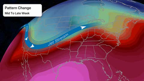
A more active severe weather pattern is developing, especially across the Plains and Midwest. According to Weather.com, strong storms are expected throughout this week into the weekend. Northern Plains states, including parts of the Dakotas and Nebraska, should watch for wind damage and large hail, especially on Wednesday night.
As the week progresses, the risk zone expands. By Thursday and Friday, areas like Wisconsin, Tennessee, and parts of the Midwest could see damaging winds, hail, and the possibility of tornadoes. The storms will often develop late in the day and may persist into nighttime hours, increasing the risk for those not monitoring the latest updates.
What Areas Are Most at Risk?
Residents in the following regions should pay particular attention to the latest weather alerts:
- The Northern Plains (the Dakotas, Nebraska)
- The Midwest, including Wisconsin, Minnesota, and Ohio
- Tennessee, Kentucky, Missouri, Arkansas, and parts of Indiana and Illinois
If you live in or near these areas, ensure you have a plan for taking shelter. According to experts, it’s important to stay informed via multiple channels, such as smartphone apps, NOAA weather radio, or local news stations.
For a detailed breakdown of the changing jet stream patterns and how warm, humid air is fueling these storms, see Weather.com's full report.
Forecast for Michigan: Cold Front Brings Storms
Michigan residents, especially in the western part of the state, should prepare for a round of strong to severe thunderstorms late Thursday as a cold front sweeps through. WZZM13.com highlights that the key time to stay weather aware is between 9 p.m. Thursday and 4 a.m. Friday. Damaging winds, heavy rain, hail, and even isolated tornadoes are possible.
The ingredients for severe weather will be present: plenty of moisture, instability in the atmosphere, a strong lifting mechanism from the approaching front, and some wind shear. For more information about these conditions and up-to-date alerts, read the detailed WZZM13 weather alert.
Staying Updated on the Latest Weather Conditions
Severe weather can develop and change quickly. Experts recommend having several ways to receive alerts and keeping an eye on the latest weather forecasts throughout the day. People in or near the affected regions should:
- Review their severe weather plan
- Know where to take shelter quickly
- Monitor forecasts from reputable sources
- Pay attention to watches and warnings
If you are near the Twin Cities, keep an eye on resources like Bring Me The News for real-time local updates.
Conclusion: Be Prepared for Shifting Weather Patterns
This week, the latest weather alerts for the Midwest and Plains signal a return to more active and potentially dangerous storms. Stay connected to trusted sources, check your emergency plans, and be ready to respond if severe storms threaten. Staying informed and prepared is the best way to stay safe as the weather shifts.