Minnesota Faces Red Flag Warning Amid Unprecedented Heat and Critical Fire Risk
Minnesota is experiencing an early-season heat wave, elevating the state's fire danger and prompting serious warnings from officials. With dry conditions and strong winds, residents are urged to stay informed and take precautions as a widespread red flag warning hovers over the region.
What Is a Red Flag Warning?
A red flag warning is issued by the National Weather Service when hot, dry, and windy weather creates critical fire risk. Under these conditions, fires can start easily and spread rapidly. In Minnesota, these warnings are taken seriously due to the state’s vast forests and grasslands.
On Mother’s Day, nearly all of Minnesota is under a red flag warning. According to MPR News, this warning is expected to persist through Tuesday as temperatures climb into the 80s and 90s, with gusty winds intensifying fire risk. Cooler areas along the North Shore offer slight relief, but much of the state remains vulnerable.
Why Is Minnesota at High Risk Now?
Several weather patterns have converged over Minnesota this week. An “Omega Block” high-pressure system has led to above-normal temperatures and very dry air. With little rainfall to moderate these conditions, the critical fire danger persists, especially across central and western parts of the state.
The Minnesota Department of Natural Resources has responded by suspending open-burning permits. Residents are strongly discouraged from lighting campfires, as even a small spark can grow into a wildfire under these circumstances.
Safety Tips During a Red Flag Warning
Staying safe during a red flag warning in Minnesota is essential. Here are some practical steps:
- Avoid all outdoor fires. This includes burning leaves, trash, or having bonfires.
- Delay or cancel recreational fires. Even contained fires can become dangerous quickly in windy, dry weather.
- Report smoke or fire immediately. Fast action can prevent a small blaze from growing out of control.
- Follow local guidelines. The Minnesota DNR will not issue permits or allow burning while the warning is in effect.
What to Expect After the Heat Wave
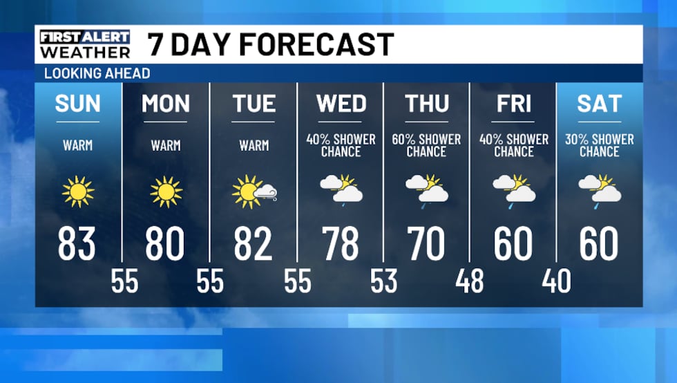
The current weather pattern is expected to last through midweek, keeping Minnesota warm and dry. Relief may be coming in the form of scattered showers. According to local meteorologists, rain could arrive by Wednesday, bringing much-needed moisture to the parched landscape.
As shared in an update from Northern News Now, the forecast predicts several rainy days after the Omega Block breaks down. Temperature will trend cooler, and rain totals could help lower fire risk for the remainder of the week.
Stay Informed and Stay Safe
Minnesota residents should keep track of the latest weather alerts and warnings, especially during periods of extreme weather. The state’s natural beauty and recreational opportunities depend on everyone doing their part to prevent wildfires. Be vigilant, practice fire safety, and check in regularly with trusted weather sources for real-time updates.
For more in-depth information and live updates on Minnesota’s fire danger and weather conditions, visit the detailed coverage at MPR News, KARE11, and Northern News Now.
Minnesota faces unique challenges this week, but with awareness and caution, communities can stay safe and minimize the risk of wildfire damage.
