Understanding Supercell Thunderstorms: Nature’s Most Powerful Storms Explained
Supercell thunderstorms are among the most impressive and powerful weather phenomena on Earth. These storms stand out for their unique structure, long lifespan, and severe weather potential. In this article, we’ll explore what makes a supercell so special, the science behind their formation, and how to spot one when skies turn dangerous.
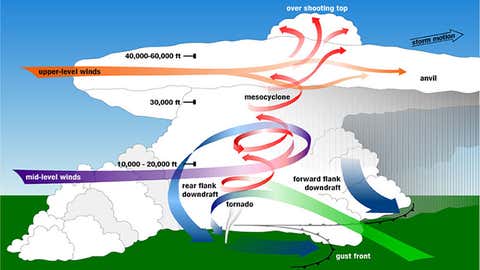
What Is a Supercell Thunderstorm?
A supercell is a type of thunderstorm distinguished by a deep, persistently rotating updraft called a mesocyclone. This rotating column of air can reach up to 50,000 feet tall and span several miles in diameter. Unlike ordinary thunderstorms, supercells are highly organized and can last for several hours while traveling long distances. This unique structure allows them to produce extreme weather such as large hail, damaging winds, and tornadoes.
As detailed by Weather.com, wind shear plays a critical role in supercell development. Wind shear occurs when wind speeds and directions change with height, causing air to spin horizontally. When a developing storm’s updraft tilts this spinning air upright, it forms the mesocyclone—the hallmark of a true supercell.
How Do Supercells Form?
For a thunderstorm to become a supercell, several key ingredients must come together:
- Moisture: Fuels the storm’s powerful updrafts.
- Instability: Creates rapid development as warm air rises quickly.
- Wind shear: Provides the necessary change in wind speed and direction with height, fostering rotation.
Meteorologist Tommy House explains on Yahoo News that this combination allows supercells to develop rotating updrafts. The result is a storm that can produce not just heavy rain, but also large hail and long-track tornadoes.
Types of Supercell Thunderstorms
Supercells are typically classified into three main categories:
- Classic Supercell: Features a prominent, rotating updraft with the potential for tornadoes, hail, and heavy rain.
- High-Precipitation (HP) Supercell: Produces intense rain and hail, sometimes obscuring tornadoes within the storm.
- Low-Precipitation (LP) Supercell: Contains less rain but can showcase picturesque tornadoes and sporadic, large hail.
Each type presents unique challenges for meteorologists and storm spotters. For example, HP supercells can produce “rain-wrapped” tornadoes that are difficult to see until it’s too late.
Why Are Supercells So Dangerous?
Supercells are responsible for most of the world’s violent tornadoes and the largest hailstones. According to Cardinal News, not every supercell spawns a tornado, but nearly all significant tornadoes come from these rotating storms. The persistent updraft and downdraft cycles enable supercells to maintain intensity and organization much longer than other thunderstorm types.
Impacts of a supercell can include:
- Tornadoes (sometimes multiple, long-lived events)
- Hail larger than golf balls or even softballs
- Damaging straight-line winds
- Flash flooding
- Frequent and intense lightning
How to Identify a Supercell
Recognizing a supercell can make a life-saving difference. Key signs include:
- A rotating, tall updraft (mesocyclone)
- Wall clouds hanging below the main storm
- Hook-shaped radar echoes, signaling rotation
- Spectacular cloud formations that may take on a sculpted or “stacked” appearance
Meteorologists use Doppler radar to track rotation within storm cells. A visible wall cloud or signs of rapid cloud base rotation are strong indicators of a supercell in the sky.
Conclusion
Supercell thunderstorms are the ultimate powerhouses of severe weather. Their unique rotating updrafts set them apart, enabling intense and long-lasting storms that can trigger tornadoes, giant hail, and destructive winds. Knowing the science behind supercells helps us prepare and stay safe when conditions turn threatening.
For more in-depth information, explore these excellent resources:
- What Is A Supercell Thunderstorm? | Weather.com
- Understanding the science and power of a supercell | Yahoo News
- What makes some thunderstorm cells 'super'? - Cardinal News
Stay alert during severe weather, and always follow updates from trusted meteorological sources. Understanding supercells can help everyone stay safer when nature unleashes its fiercest storms.